

Warm, cloudy conditions expected over large parts of SA.
The South African Weather Service has issued an alert for severe thunderstorms that come with hail and strong winds over parts of Limpopo and Mpumalanga. Cloudy and warm conditions with some fog patches are expected over large parts of the country.
Impact-based warning
A Yellow Level 2 warning has been issued for severe thunderstorms with heavy downpours that could lead to possible localised flooding, hail and strong, damaging winds over the eastern parts of Limpopo and Mpumalanga.
Fire danger warning
Extremely high fire danger conditions are expected in places over the eastern parts of the Northern Cape as well as the Bergrivier Local Municipality of the Western Cape.
Tomorrow’s Weather: Tue, 12 Dec 2023:
Partly cloudy with isolated to scattered showers
and thundershowers over eastern and southern parts,
otherwise fine and cool to warm.Tomorrow’s Warning(s): Tue, 12 Dec 2023
A. Yellow L2: Severe Thunderstorms.
(See details on Warnings map. pic.twitter.com/XRmClWip09— SA Weather Service (@SAWeatherServic) December 11, 2023
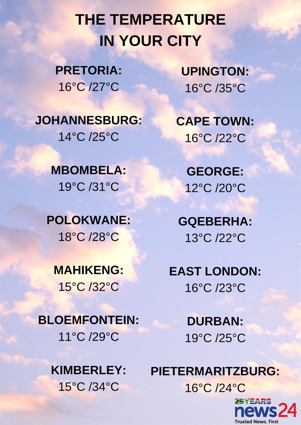
Weather in your region
Gauteng can expect morning fog in the south, otherwise it will be partly cloudy and warm with isolated showers and thundershowers.
The expected UVB sunburn index is very high.
It will be cloudy and cool to warm in Mpumalanga, with isolated showers and thundershowers which will be scattered in the east.
Limpopo will be cloudy and warm with isolated showers and thundershowers which will be scattered in the east.
Morning fog is expected in places over the North West province, otherwise it will be fine and warm to hot but partly cloudy in the extreme east where isolated showers and thundershowers are expected.
The Free State can expect morning fog in places, otherwise fine and warm to hot but partly cloudy conditions are expected in the east where isolated showers and thundershowers are forecast.
Morning fog is expected along the coast in the Northern Cape, otherwise it will be fine and warm to hot, but cool along the coast.
The wind along the coast will be fresh to strong southerly to south-easterly.
It will be cloudy along the coast and adjacent interior of the Western Cape, otherwise partly cloudy and cool to warm conditions are expected with isolated to scattered showers and rain in the southern parts of the province.
The wind along the coast will be fresh to strong south-westerly to southerly along the south coast becoming moderate to fresh south-easterly, otherwise fresh to strong south-easterly.
The expected UVB sunburn index is extreme.
Partly cloudy and cool conditions are expected in the western half of the Eastern Cape, with isolated showers but scattered along the coast and adjacent interior where it will be cloudy. It will be warm in the north.
The wind along the coast will be light to moderate westerly, becoming southerly by mid-day.
It will be partly cloudy and cool to warm in the eastern half of the province, with isolated showers and thundershowers which will be scattered south of the escarpment where it will be cloudy.
The wind along the coast will be moderate to fresh south-westerly, becoming southerly by late afternoon.
KwaZulu-Natal will be cloudy and warm with isolated showers and thundershowers which will be scattered along the coast and adjacent interior. It will be cool in the south-west.
The wind along the coast will be moderate to fresh south-westerly.
The expected UVB sunburn index is very high.


Recent Comments