

Snow, cold fronts and heavy downpours are expected in several regions on Thursday. (Busang Senne/News24)
The South African Weather Service has issued an advisory for snowfall and a cold front with heavy downpours expected in multiple provinces.
Impact-based warnings
A Yellow Level 2 warning for damaging waves resulting in difficulty in navigation at sea, and small vessels at risk of taking on water and capsizing, is expected between Saldanha Bay and Plettenberg Bay in the evening.
Advisories
Cold, wet and windy weather conditions are expected over the Eastern Cape on Friday, 5 July, due to a passing cold front associated with its upper-air trough.
Snowfalls are expected over the high-lying areas of the Eastern Cape and very rough to high seas are forecast from Friday afternoon into Saturday.
Meanwhile, another intense cold front is expected to affect the Western Cape and Northern Cape on Sunday, 7 July, into Monday, 8 July.
The public and small stock farmers are advised that heavy downpours, snowfalls, very cold conditions, strong coastal and interior winds and very rough seas can be expected over those areas.
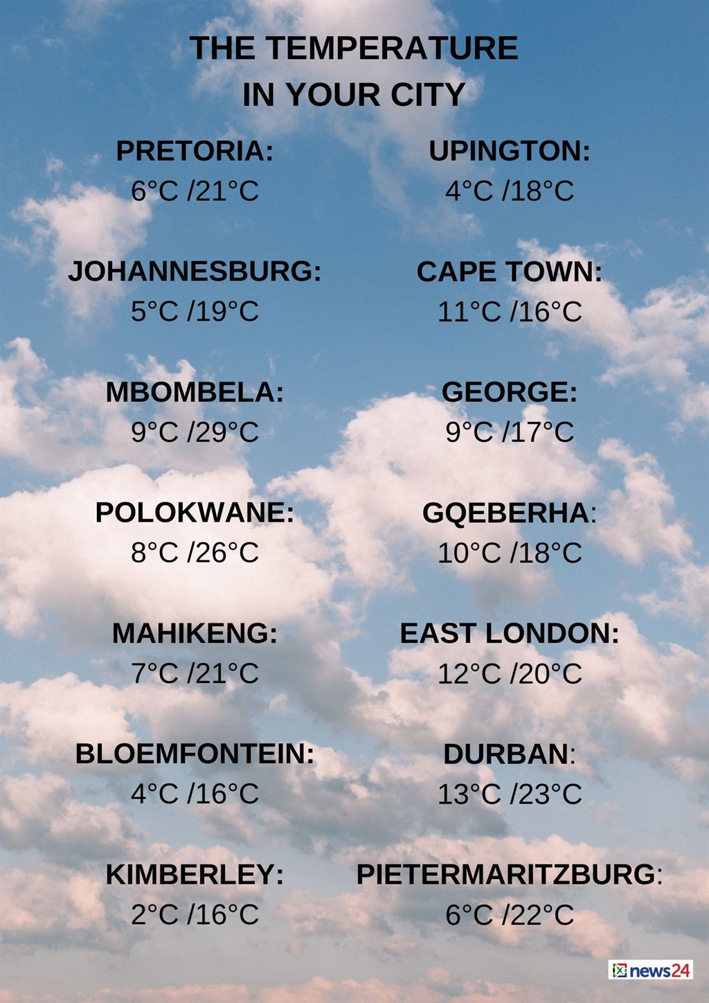
The weather in your region
Fine and cool temperatures are forecast in Gauteng, but it will be warm in the north.
The expected UVB sunburn index is very high.
Mpumalanga can expect fine and cold to cool conditions but it will be warm in places in the east.
Fine and cool to warm temperatures are forecast in Limpopo, but expect hot temperatures in places in the Lowveld and the Limpopo Valley.
The North West will be fine, windy and cool to warm.
Fine, windy and cold to cool conditions are expected in the Free State, becoming partly cloudy in the south.
The Northern Cape will be partly cloudy in west with morning fog patches. Otherwise, fine, windy and cold to cool temperatures are forecast, becoming partly cloudy in the south from the afternoon.
The wind along the coast will be light and variable at first, otherwise a moderate to fresh southerly is expected.
Partly cloudy conditions are forecast over the western parts and along the south coast of the Western Cape in the morning.
Otherwise, it will be fine and cold.
Morning fog patches are expected over the West Coast, with light rain over the south-western parts from the evening.
The wind along the coast will be a moderate to fresh west to north-westerly, but strong at times along the south coast, while including the south-west coast from the evening, where it will reach near-gale towards midnight.
The expected UVB sunburn index is low.
Light snowfalls over some of the Eastern Cape interior tomorrow. Another cold front approaches the Western Cape, bringing some isolated to scattered showers. Damaging waves to be expected between Saldanha Bay and Plettenberg Bay. Weather clearing towards the weekend.?????? pic.twitter.com/Ql3Xkw1Oiq
— SA Weather Service (@SAWeatherServic) July 3, 2024
The western half of the Eastern Cape will be cloudy with isolated showers over the eastern parts in the morning, otherwise fine and cold conditions are forecast.
The wind along the coast will be a fresh to strong westerly.
Cloudy conditions are forecast in the eastern half of the province with isolated showers in the west and light snowfalls in the north-east in the morning.
Otherwise, partly cloudy and cold temperatures are expected but it will be cool along the coast.
The wind along the coast will be a moderate to fresh south-westerly.
KwaZulu-Natal can expect fine and cool to warm temperatures, but it will be cold in the south-west.
It will become partly cloudy in the east with isolated showers along the north coast and adjacent interior.
The wind along the coast will be a moderate northerly to north-easterly in the north in the morning.
Otherwise, a moderate to fresh southerly to south-westerly is expected, becoming strong to near gale from mid-morning.
The expected UVB sunburn index is high.


Recent Comments