

High fire risk is expected in at least four provinces. (Sean Gladwell/Getty Images)
The South African Weather Service has forecast a high risk of fires in at least four provinces, but cold, wet and windy conditions are expected elsewhere in the country.
Impact-based warnings
An Orange Level 5 warning for a storm surge has been issued for the coast between Plettenberg Bay and Buffalo City, leading to flooding of low-level coastal regions, especially estuaries.
Disruptions to small harbours/ports and damage to beaches, dunes and estuaries – as well as breaching of river banks upstream – are also expected.
A Yellow Level 2 warning has been issued for disruptive rain resulting in flooding of roads and susceptible settlements, as well as vehicle accidents due to slippery roads and reduced visibility over the south-western parts of the Western Cape.
A Yellow Level 2 warning for damaging winds and waves leading to difficulty in navigation at sea of small vessels and personal watercraft has been issued for between Plettenberg Bay and East London.
Fire danger warnings
Extremely high fire danger conditions are expected in Limpopo’s Modimolle Local Municipality, the eastern parts of the Free State and North West, and the southern parts of Gauteng.
Advisories
Very cold, wet and windy conditions are forecast in parts of Namakwa in Northern Cape and the Witzenberg in Western Cape.
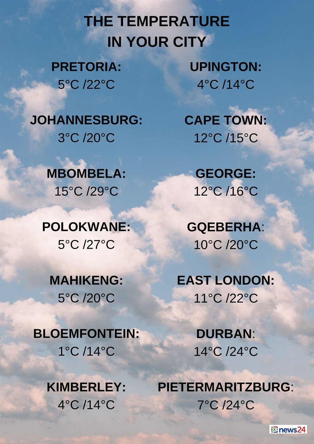
The weather in your region
Gauteng will be fine and cool, but warm in the extreme north.
The expected UVB sunburn index is high.
Fine and cool to warm temperatures are expected in Mpumalanga, but it will be hot in the Lowveld.
Limpopo can expect fine and warm conditions, but hot temperatures in the Lowveld and Limpopo Valley.
Fine, windy and cool conditions are forecast in the North West, but it will be partly cloudy over the western parts.
The Free State will be fine, windy and cold to cool but partly cloudy in the south-west.
Morning fog is expected over the central parts of the Northern Cape.
Otherwise, it will be cloudy and cold to cool with isolated showers and thundershowers, except in the extreme east where it will be partly cloudy.
It will be windy in places over the western interior.
The wind along the coast will be a moderate to fresh northerly to north-westerly.
The Western Cape can expect cloudy conditions and cold to cool temperatures, with isolated to scattered showers, but widespread in the extreme south-west.
It will be windy over the eastern parts.
The wind along the coast will be a fresh to strong north-westerly to westerly, becoming moderate to fresh south-westerly between Slangkop and Cape Agulhas from the afternoon.
The expected UVB sunburn index is low.
Morning frost is expected in places over the western half of the Eastern Cape, otherwise it will be fine, windy and cold to cool.
It will become cloudy with isolated showers and rain from the afternoon, but scattered along the coast.
The wind along the coast will be a light to moderate north-westerly, becoming strong to gale force westerly from late morning.
The eastern half of the province will have morning frost in places. Otherwise, it will be fine, windy and cold to cool, becoming cloudy from the evening with isolated showers and rain north of the escarpment where light snow is expected.
The wind along the coast will be a light to moderate north-westerly, becoming fresh to strong south-westerly in the afternoon.
KwaZulu-Natal will be fine and cool, but warm in the north-east.
The wind along the coast will be a gentle north-westerly in the morning. Otherwise, a moderate to fresh north-easterly wind is expected.
It will become a moderate to fresh south-westerly from the south during the evening.
The expected UVB sunburn index is very high.


Recent Comments