

Cloudy and cool to warm conditions are expected in large parts of SA.
The South African Weather Service has warned of thunderstorms in a number of provinces for the weekend, with cloudy and cool to warm conditions expected in most parts of the country.
Impact-based warning:
A Yellow Level 2 warning has been issued for severe thunderstorms that will produce strong wind and large amounts of small hail, which will result in localised damage to property, localised short-term disruption to municipal and other essential services.
Localised flooding is also expected along susceptible roads and low-lying areas and bridges are expected over the northern-eastern parts of the Eastern Cape, extreme north-eastern parts of the Northern Cape, as well as the Free State and North West province, except their extreme eastern parts.
?????Weather outlook for Saturday, 04 November 2023.
Isolated to scattered showers and thundershowers are expected over the central and eastern parts of the country.
Otherwise, partly cloudy and cool, but warm over the northern parts of the Northern Cape. #saws pic.twitter.com/xAu6S7Wd0D— SA Weather Service (@SAWeatherServic) November 3, 2023
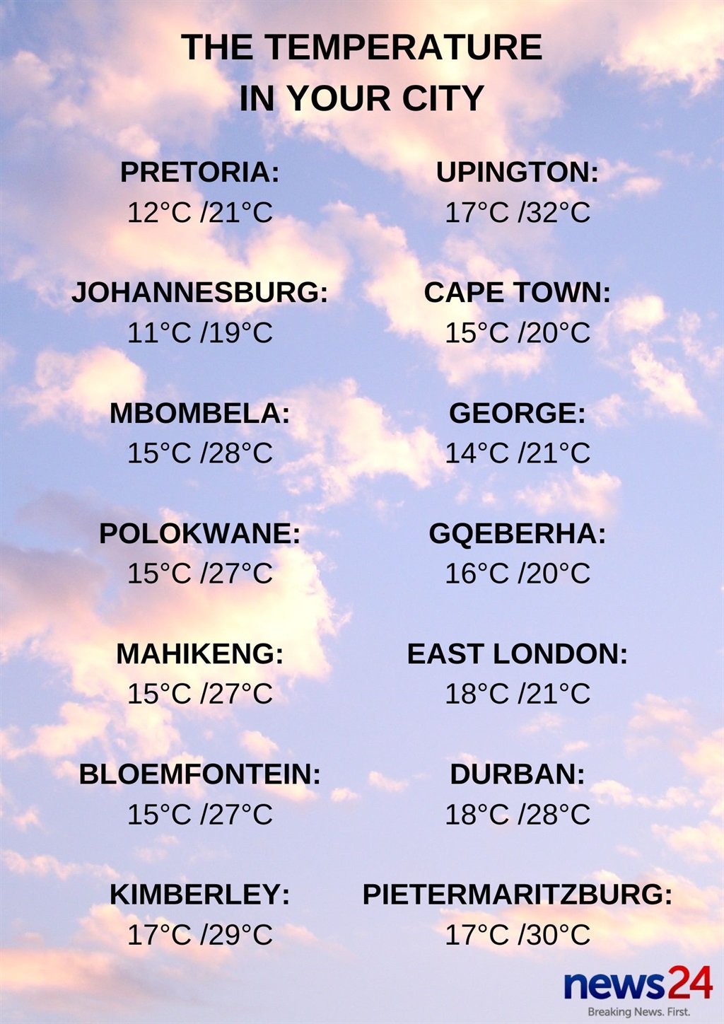
Weather in your province:
Gauteng will be cloudy and cool with isolated showers and thundershowers.
The expected UVB sunburn index is low.
Morning fog patches are expected along the escarpment of Mpumalanga, otherwise it will be partly cloudy and warm, with isolated afternoon showers and thundershowers in the extreme south-western parts of the province.
Limpopo can expect partly cloudy and warm conditions, becoming cloudy with isolated afternoon showers and thundershowers over the south-western bushveld.
It will be cloudy and warm in the North West, with scattered showers and thundershowers, but isolated in the extreme eastern parts of the province.
The Free State will be cloudy and warm, with scattered showers and thundershowers.
It will be partly cloudy and warm to hot with isolated showers and thundershowers in the eastern parts of the Northern Cape, but cloudy and scattered in the extreme north-east. It will be cool in places over the Namakwa district.
The wind along the coast will be fresh southerly to south-westerly, becoming strong north of Port Nolloth by the evening.
Cloudy and cool to warm conditions can be expected in the Western Cape, with morning isolated showers and rain in the west and south-western parts, spreading to the south-coast by the afternoon.
The wind along the coast will be moderate to fresh south-westerly but strong westerly along the south coast in the morning.
The expected UVB sunburn index is very high.
It will be cool in places along the coast, otherwise partly cloudy and warm in the western half of the Eastern Cape. It will become cloudy with isolated showers and thundershowers in the north and extreme east.
The wind along the coast will be moderate to fresh south-westerly.
The eastern half of the province will be partly cloudy and cool, becoming cloudy with scattered showers and thundershowers.
KwaZulu-Natal can expect partly cloudy and warm conditions, that will become cloudy in the afternoon with scattered showers and thundershowers in the south, otherwise isolated except in extreme north-east.
The wind along the coast will be moderate to fresh north-easterly.
The expected UVB sunburn index is moderate.


Recent Comments