

Snow, fires, fog and rain are expected in multiple parts of the country over the weekend. (Muhammed Saloojee/Supplied)
The South African Weather Service has forecast a mixed bag of conditions over the weekend, with a risk of fires, possible snowfall, morning fog and disruptive rain expected in multiple regions across the country.
Impact-based warnings
A Yellow Level 2 warning for damaging winds leading to difficulty in navigation at sea is expected between Cape Point and East London into Sunday.
A Yellow Level 2 warning for damaging waves is also expected between Cape Agulhas and Plettenberg Bay from Saturday afternoon into Sunday evening, and could lead to possible coastal infrastructure damage in exposed bays.
A Yellow Level 2 warning for disruptive rain resulting in flooding of settlements, roads, low-lying areas and bridges is expected in places over the coastal regions and adjacent interior of the western parts of the Eastern Cape.
Fire danger warnings
Extremely high fire danger conditions are expected over the extreme eastern part of the Northern Cape, western part of the Free State and south-western part of the North West.
Advisories
A cut-off low pressure system is expected to result in cold, wet and windy conditions over southern high-lying areas of the Namakwa region of the Northern Cape as well as the central and eastern interior of the Western Cape on Saturday, spreading to the rest of the Northern Cape interior, Eastern Cape interior and Free State as well along Lesotho borders from Sunday to Monday.
There will be possible light snowfalls in places over the high ground of the Eastern Cape, as well as Lesotho.
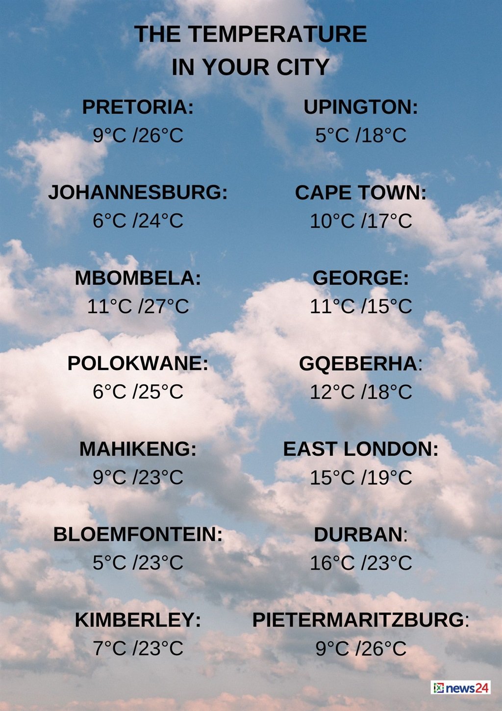
The weather in your region
Fine and cool conditions are forecast for Gauteng.
The expected UVB sunburn index is high.
Mpumalanga can expect fine and cool temperatures, but it will be warm in the Lowveld.
Fine and cool to warm conditions are expected in Limpopo.
The North West will be fine, windy and cool to warm, becoming partly cloudy in the extreme west.
Fine temperatures are forecast in the central and eastern parts of the Free State. Otherwise, it will be partly cloudy, windy and cool to warm, with isolated showers and thundershowers in the south.
Cloudy conditions are expected in the Northern Cape’s southern regions. Otherwise, partly cloudy and cold to cool temperatures are forecast, with isolated showers and thundershowers in the south east.
Fine temperatures are forecast in the extreme west, with morning fog patches in the south.
The wind along the coast will be light and variable becoming a light south-easterly to easterly from the evening.
The Western Cape can expect cloudy and cold to cool temperatures with isolated to scattered showers and rain along the south coast and adjacent interior.
Morning fog patches are expected in the west.
The wind along the coast will be light and variable in the west becoming a light to moderate south-easterly from the evening.
Otherwise, a moderate to fresh easterly reaching strong to gale from the afternoon is expected.
The expected UVB sunburn index is low.
??????Weather outlook for Saturday & Sunday, 1 – 2 June 2024.Central and southern areas of the country will result in cold, wet & windy conditions as there will be a Cut-off-Low over the western areas of the country, associated with a surface high over the southern areas. #saws pic.twitter.com/HTXWIC1plA
— SA Weather Service (@SAWeatherServic) May 30, 2024
Cloudy and cold to cool temperatures are forecast in the western half of the Eastern Cape with scattered showers and rain, but widespread along the coast and adjacent interior.
Isolated showers and thundershowers are expected in the north-east.
The wind along the coast will be a strong to gale force south-easterly.
The eastern half of the province will be cloudy and cold to cool with isolated showers and thundershowers in the north-east but scattered over interior.
Widespread showers and rain are forecast in the south-west.
The wind along the coast will be a strong to gale force easterly.
KwaZulu-Natal will have morning fog over the interior, otherwise partly cloudy and cool conditions are forecast but it will be warm in the north-east.
It will become cloudy in the afternoon with isolated showers and rain in the south and east up to Richards Bay.
The wind along the coast will be a gentle to moderate northerly to north-easterly, becoming a fresh southerly to south-westerly south of Durban from late morning, spreading northwards.
The expected UVB sunburn index is moderate.


Recent Comments