

Extremely hot weather conditions are expected in at least three provinces.
Chuchart Duangdaw/Getty Images
Damaging winds and extremely high fire danger conditions are expected in the central and northern parts of the country, according to the South African Weather Service.
Impact-based warnings:
– A yellow level 2 warning for damaging winds, which is expected to result in the spread of runaway fires over the central and northern parts of the Western Cape as well as the south-western parts of the Northern Cape.
– A yellow level 2 warning for damaging coastal winds between Dassen Island and Still Bay, which could result in difficulty in navigation at sea.
Fire danger warnings:
Extremely high fire danger conditions are expected over the western parts of the Eastern Cape, the northern and central parts of the Western Cape, as well as the central and southern interior of the Northern Cape.
Advisories:
A heatwave is expected daily, up to at least Saturday, with persistently high temperatures in places over the central interior and in the western region of the Eastern Cape.
??Weather Alerts for tomorrow, 29 January 2024:A. Yellow level 2 warning: Damaging winds over the central and northern parts of Western Cape and south-western parts of the Northern Cape.B. Yellow level 2 warning: Damaging coastal winds between Dassen Island and Still Bay. pic.twitter.com/1e0xgVdTpN
— SA Weather Service (@SAWeatherServic) January 28, 2024
Weather outlook for Tomorrow, 29 January 2024:
Partly cloudy and warm to hot with isolated to scattered showers and thundershowers over the central and eastern interior. It will be very hot to extremely hot in the west with light rain in the extreme south-west. pic.twitter.com/DASlgZlIuj
— SA Weather Service (@SAWeatherServic) January 28, 2024
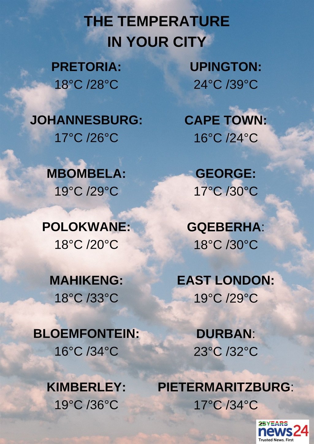
The weather in your region:
Gauteng will be partly cloudy and warm, with isolated afternoon showers and thundershowers.
The expected UVB sunburn index is extreme.
Mpumalanga will be partly cloudy and warm, with isolated showers and thundershowers, except in the Lowveld, where it will be hot, but scattered along the escarpment.
It will be partly cloudy and warm, with isolated showers and thundershowers, in Limpopo, except in the east, where it will be hot.
It will be fine in the eastern part of the North West at first, otherwise partly cloudy and warm to hot, with isolated showers and thundershowers.
Free State will be fine and warm to hot, becoming partly cloudy in the afternoon, with isolated showers and thundershowers.
Morning fog patches can be expected along the coast in the Northern Cape, otherwise fine and warm to hot, but very hot in places in the north.
It will become partly cloudy, with isolated showers and thundershowers in the eastern and northern parts.
The wind along the coast will be light and variable, but moderate south-westerly during the afternoon.
The Western Cape will be fine and warm to hot, but very hot to extremely hot and very windy in the east.
It will become cloudy, with isolated showers and rain along the south-west coast in the evening.
The wind along the coast will be fresh to strong north-westerly, reaching near gale to gale between Dassen Island and Still Bay in the afternoon.
The expected UVB sunburn index is extreme.
The western half of the Eastern Cape will be fine and warm to hot, but very hot to extremely hot in places over the interior, becoming partly cloudy, with isolated thundershowers in places over the interior and south-east.
The wind along the coast will be light to moderate easterly, becoming moderate to fresh south-westerly in the evening.
The eastern half of the province will be fine and warm to hot, becoming partly cloudy, with isolated thundershowers in places in the north-east.
The wind along the coast will be moderate to fresh north-easterly, becoming strong in the evening.
KwaZulu-Natal will be fine and warm to hot, becoming partly cloudy in the afternoon, with scattered showers and thundershowers in the west, otherwise isolated, except in the north-east.
The wind along the coast will be moderate to fresh, easterly to north-easterly.
The expected UVB sunburn index is extreme.


Recent Comments