
Extremely hot conditions are expected in parts of SA.
While the heatwave continues in some parts of the country, isolated thundershowers are expected over the central and south-eastern interior, spreading along the escarpment of Mpumalanga, becoming scattered along the Wild Coast into the central interior of KwaZulu-Natal, according to the South African Weather Service.
Fire danger weather
Extremely high fire danger conditions are expected over the Limpopo Valley, south-western Bushveld in Limpopo, parts of the North West, northern parts of the Free State and over the extreme north-eastern parts of the Northern Cape.
Advisories
Heatwave conditions resulting in persistently high temperatures over and above the average maximum are expected over the eastern parts of the North West and Gauteng, the Limpopo Valley and western Bushveld, spreading to the central and northern parts of Free State on Sunday, persisting until Tuesday.
Tomorrow’s Weather Update: 04 December 2023
Isolated thundershowers are expected over the central & south-eastern interior, spreading along the escarpment of Mpumalanga, becoming scattered along the Wild Coast into the central interior of KwaZulu-Natal.#southafricanweather pic.twitter.com/e6bXMtfodD— SA Weather Service (@SAWeatherServic) December 3, 2023
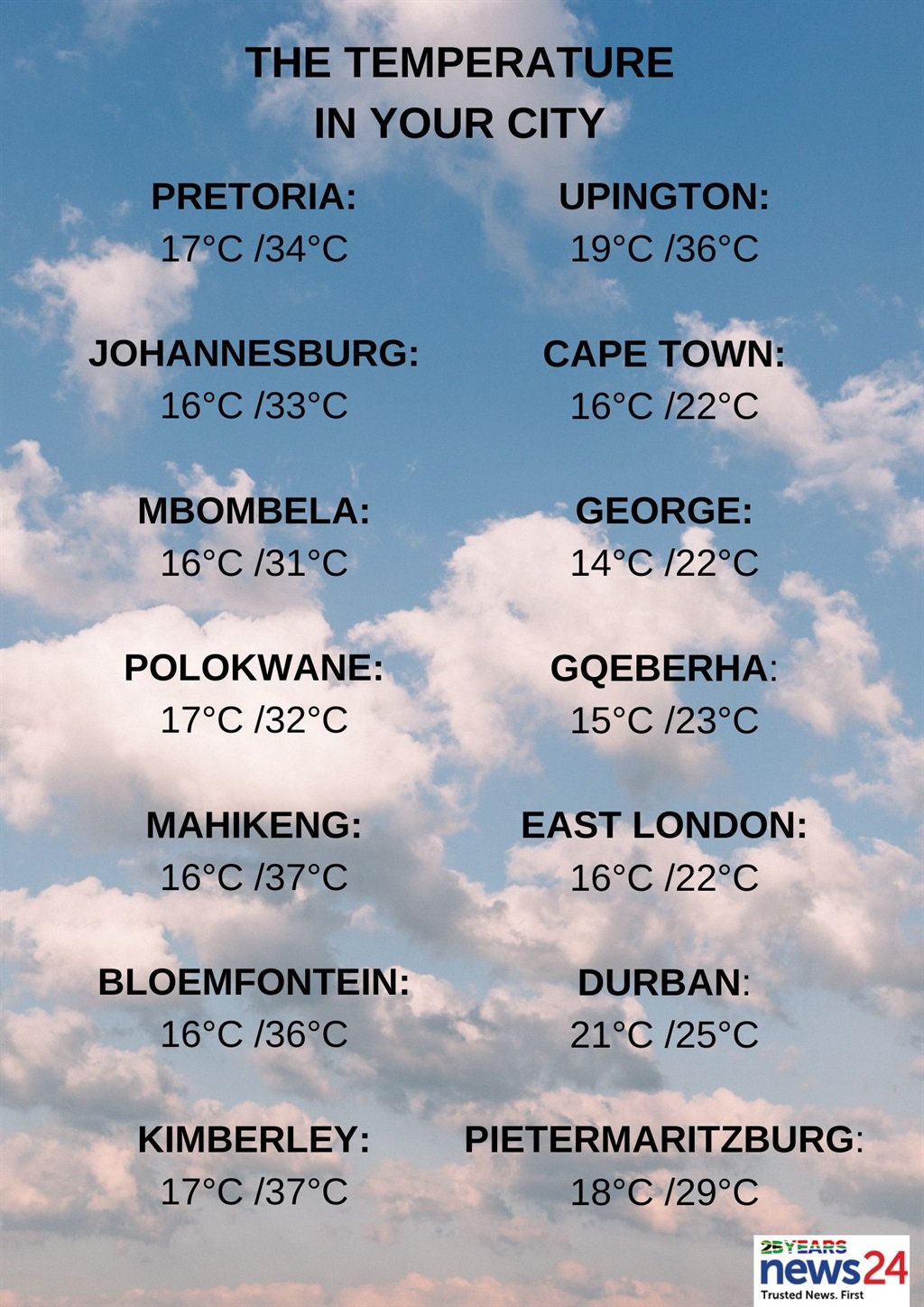
The weather in your province
Gauteng will be partly cloudy and hot.
The expected UVB sunburn index is extreme.
Mpumalanga will be cloudy over the south-eastern Highveld in the morning with fog patches, otherwise fine and warm to hot but very hot in places in the Lowveld. It will become partly cloudy on the Highveld in the afternoon with isolated thundershowers over the eastern Highveld.
Limpopo will experience fine and hot to very hot but extremely hot in places in the western Bushveld. It will become partly cloudy in the south-west from the afternoon.
It will be fine in the east of the North West at first, otherwise partly cloudy and hot to very hot, with isolated showers and thundershowers in the extreme west.
Partly cloudy and warm to hot with isolated showers and thundershowers can be expected in the central Free State, western and extreme eastern parts.
Northern Cape will be fine and cool to warm in the west, otherwise partly cloudy and hot to very hot with isolated showers and thundershowers in the extreme north-east.
The wind along the coast will be moderate to fresh southerly to south-easterly.
The Western Cape will also be fine and cool to warm, but partly cloudy along the south coast and adjacent interior. The wind along the coast will be moderate to fresh southerly to south-easterly, otherwise south-westerly to westerly south of Cape Point.
The expected UVB sunburn index is extreme
The western half of the Eastern Cape will be partly cloudy and cool to warm, with drizzle in the extreme south-east.
The wind along the coast will be light westerly in the morning, otherwise moderate to fresh south-westerly.
On the eastern half of the province, there will be light morning rain in places south of the escarpment, otherwise partly cloudy and cool with isolated showers and thundershowers, but scattered in the south-east. It will be partly cloudy, windy and warm in the north.
The wind along the coast will be light to moderate south-westerly, becoming moderate to fresh south-easterly north of Mazeppa Bay in the afternoon.
KwaZulu-Natal will be partly cloudy and hot, but warm in the south with scattered showers and thundershowers expected in the south, otherwise isolated except in the north-east.
The wind along the coast will be moderate south-westerly in the south of Richards Bay, otherwise moderate to fresh north-easterly.
The expected UVB sunburn index is extreme.


Recent Comments