

Heatwave conditions that exceed the average maximums and fire danger warnings are forecast in several areas across SA.
Chuchart Duangdaw/Getty Images
The South African Weather Service has issued an advisory for heatwave conditions with persistently high temperatures, and a fire danger warning, in several regions across the country.
Impact-based warnings
A Yellow Level 1 warning has been issued for severe thunderstorms resulting in flash flooding and damaging wind gusts which could cause structural damage in the Overberg and Garden Route coast in the Western Cape.
A Yellow Level 2 warning has been issued for wind and waves leading to small vessels and personal watercraft at risk of taking on water and capsizing between Cape Agulhas and Port Alfred.
Fire danger warnings
Extremely high fire danger conditions are expected in Gauteng, Limpopo and Mpumalanga, as well as the Walter Sisulu Municipality of the Eastern Cape.
Advisories
Heatwave conditions resulting in persistently high temperatures that exceed the average maximums are expected in places in Gauteng and the southern and central parts of Mpumalanga until Saturday.
?????Weather outlook for Friday, 16 February 2024:
Partly cloudy and cool to warm with isolated to scattered showers and thundershowers in the east and south. It will be hot to very hot in the north-east but extremely hot in the extreme north-east. pic.twitter.com/PsFDekXwFx
— SA Weather Service (@SAWeatherServic) February 15, 2024
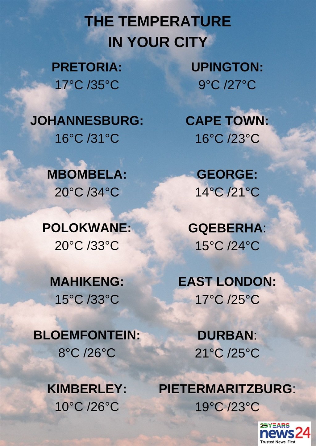
The weather in your region
Gauteng will be fine in the morning.
Otherwise, partly cloudy and hot but very hot conditions are expected in places in the north, with isolated showers and thundershowers by the evening.
The expected UVB sunburn index is extreme.
Mpumalanga will be partly cloudy with warm to hot but very hot temperatures in the Lowveld, and isolated showers and thundershowers over the central areas and Highveld.
Partly cloudy conditions with isolated showers and thundershowers are forecast for Limpopo in the western Bushveld and in the south-west.
Fine, windy and warm to hot temperatures are expected in the North West, becoming partly cloudy with isolated showers and thundershowers over the extreme eastern parts.
The Free State can expect fine, windy and cool to warm conditions, becoming partly cloudy over the east with isolated showers and thundershowers.
Partly cloudy conditions are forecast in the south and central Northern Cape.
Otherwise, fine and cool to warm but hot temperatures are expected in places over the east.
The wind along the coast will be a moderate to fresh southerly to south-westerly.
The Western Cape will be partly cloudy with cool to warm conditions, but cloudy along the south coast and adjacent interior where isolated to scattered showers and thundershowers are expected.
The wind along the coast will be a moderate to fresh south-easterly along the west coast.
Otherwise, a fresh to strong southerly to south-westerly wind is expected.
The expected UVB sunburn index is very high.
Cloudy and cool conditions are forecast for the western half of the Eastern Cape, with isolated showers and thundershowers south of the escarpment, scattered in the extreme south-west.
The wind along the coast will be a light to moderate north-westerly, becoming fresh to strong westerly by midday.
The forecast for the eastern half of the province is cloudy and cool with isolated showers in places south of the escarpment.
The wind along the coast will be a light to moderate south-westerly, becoming light and variable from late afternoon.
KwaZulu-Natal will be cloudy along the coast and adjacent interior.
Otherwise, partly cloudy with warm to hot temperatures are expected in places in the north, with isolated showers and thundershowers.
The wind along the coast will be a fresh to strong southerly to south-westerly south of Richards Bay, otherwise a strong northerly to north-easterly is expected.
The expected UVB sunburn index is extreme.


Recent Comments