

The South African Weather Service has warned of thunderstorms that could lead to flooding in parts of the Eastern and Northern Cape provinces.
The South African Weather Service issued a warning for severe thunderstorms in parts of the Eastern Cape and Northern Cape. It will be cloudy and fine to cool elsewhere in the country.
Impact-based warning:
A Yellow Level 2 warning for severe thunderstorms, leading to strong winds, heavy downpours and hail, which will result in localised damage to property and localised short-term disruption to municipal and other essential services. Localised flooding can be expected along susceptible roads, low-lying areas and bridges over the central and western parts of the Eastern Cape, as well as the eastern parts of the Northern Cape, except in the extreme north-eastern parts of the province.
Fire danger warning:
Extremely high fire danger conditions are expected over the central parts of the Northern Cape, as well as the central and north-eastern interior of the Western Cape.
?????Weather outlook for tomorrow, 03 November 2023.showers and thundershowers are expected over the central and western areas of the country. Otherwise, partly cloudy and cool conditions.??Warning: Severe thunderstorms- Eastern Cape, Northern Cape and Free State.#saws pic.twitter.com/R61WiwYZDI
— SA Weather Service (@SAWeatherServic) November 2, 2023
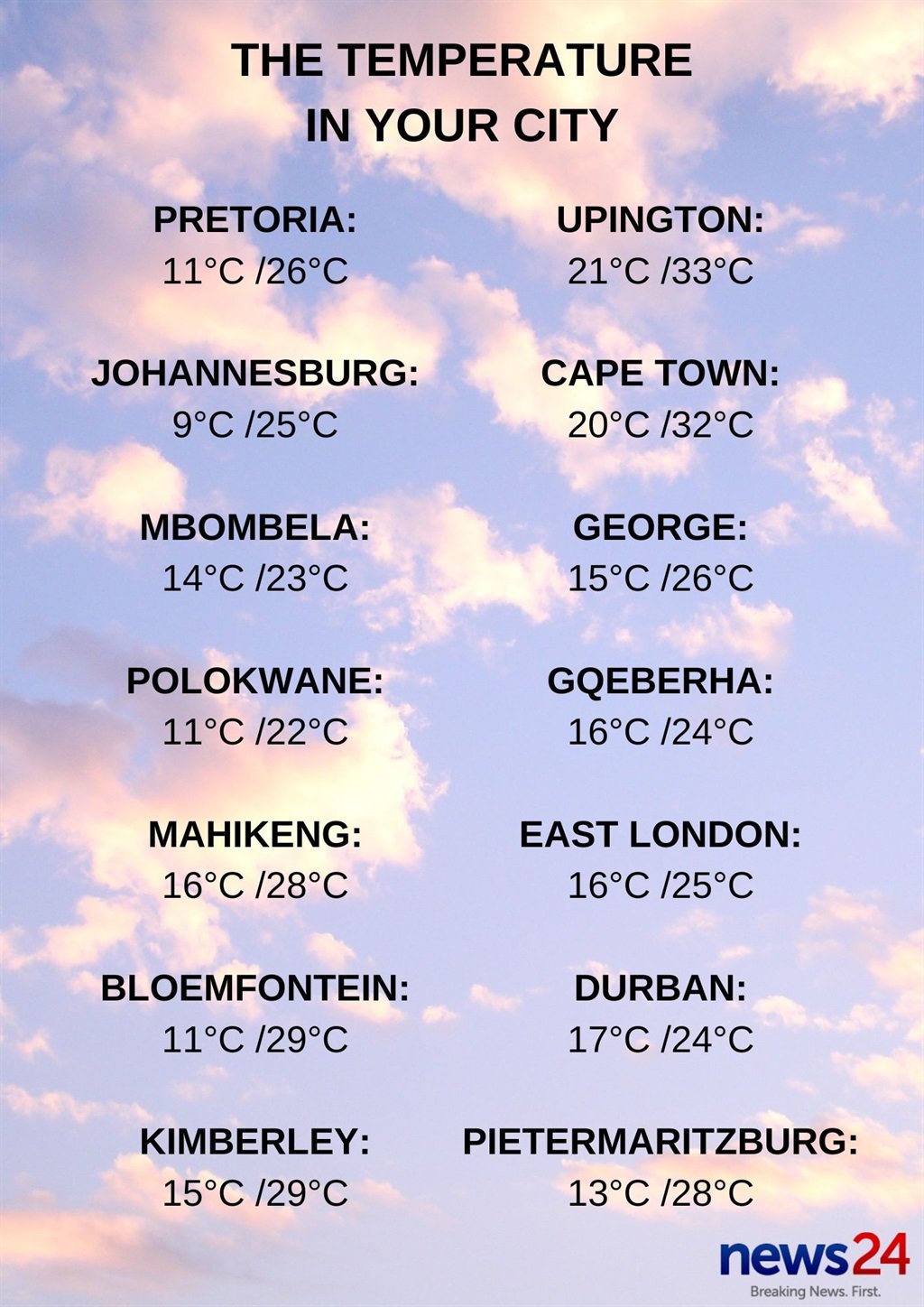
Weather in your province:
Gauteng will be partly cloudy and warm.
The expected UVB sunburn index is high.
It will be cloudy in the eastern parts of Mpumalanga, with morning fog patches and drizzle along the escarpment, otherwise partly cloudy and cool.
Warm conditions are expected in the lowveld.
Limpopo will be cloudy in the east, with morning fog patches and drizzle along the escarpment, otherwise it will be partly cloudy and cool to warm.
It will be fine in the central and eastern parts of the North West at first, otherwise partly cloudy and warm conditions are forecast.
There will be isolated showers and thundershowers in the northern and western parts of the province.
The Free State can expect morning fog in places in the extreme east, otherwise partly cloudy and warm, with isolated showers and thundershowers in the west, as well in the extreme east.
It will be windy in the western parts of the province.
It will be cloudy and cool in the western parts of the Northern Cape, with morning fog in the extreme north-west.
Partly cloudy and warm to hot weather is expected, with isolated to scattered showers and thundershowers in the east, where it will be windy.
The wind along the coast will be light to moderate westerly to north-westerly, becoming fresh southerly to south-westerly in the evening.
Cloudy and cool conditions are expected along the Western Cape coast, with light rain in the south-west by the evening, otherwise it will be partly cloudy and warm, but hot over the eastern interior.
Isolated showers and thundershowers are expected over the extreme north-eastern interior from the afternoon.
The wind along the coast will be moderate to fresh north-westerly along the West Coast, spreading to the south coast in the afternoon and reaching strong along the south-west coast.
It will become southerly to south-westerly along the south-west coast from the evening.
The expected UVB sunburn index is very high.
It will be cool along the coast in the western half of the Eastern Cape, but otherwise partly cloudy and hot to very hot, becoming cloudy, with scattered showers and thundershowers in the afternoon, and into the evening.
The wind along the coast will be moderate to fresh easterly, reaching strong east of St Francis, becoming moderate to fresh westerly west of Oyster Bay in the afternoon, spreading east in the evening.
The eastern half of the province will be cloudy at first, with morning fog in places south of the escarpment, otherwise partly cloudy and warm to hot.
It will become cloudy, with scattered thundershowers in the evening, but isolated in the extreme east.
The wind along the coast will be moderate to fresh north-easterly, becoming strong in the afternoon.
KwaZulu-Natal can expect morning fog over the interior, otherwise it will be partly cloudy and cool to warm, with isolated showers and thundershowers in the south-west and Midlands.
The wind along the coast will be moderate easterly to north-easterly, freshening in the afternoon.
The expected UVB sunburn index is very high.


Recent Comments