

The will be damaging winds, small amounts of hail and heavy downpours on Friday in some parts of the country.
The South African Weather Service has forecast damaging winds, some hail and heavy downpours leading to localised flooding in parts of the Northern Cape, North West, Free State and KwaZulu-Natal.
Impact based warning
Yellow level 2 warning for severe thunderstorms resulting in strong damaging winds, some hail and heavy downpours leading to localised flooding of vulnerable settlements, low-lying areas, bridges, and major roads are expected over the extreme eastern parts of the Northern Cape, North West, Free State, western interior of KwaZulu-Natal, southern highveld of Mpumalanga and western Bushveld of Limpopo.
Fire danger warnings
Extremely high fire danger conditions are expected in places over the extreme northern parts of the Northern Cape.
?Weather outlook for tomorrow, Partly cloudy and warm, but cool in places in the east with scattered to isolated thunderstorms expected over the central and eastern areas of the country. ??Weather alert: Severe thunderstorms: Hail, damaging winds and heavy rain.#saws pic.twitter.com/r4xAdaqbfL
— SA Weather Service (@SAWeatherServic) December 14, 2023
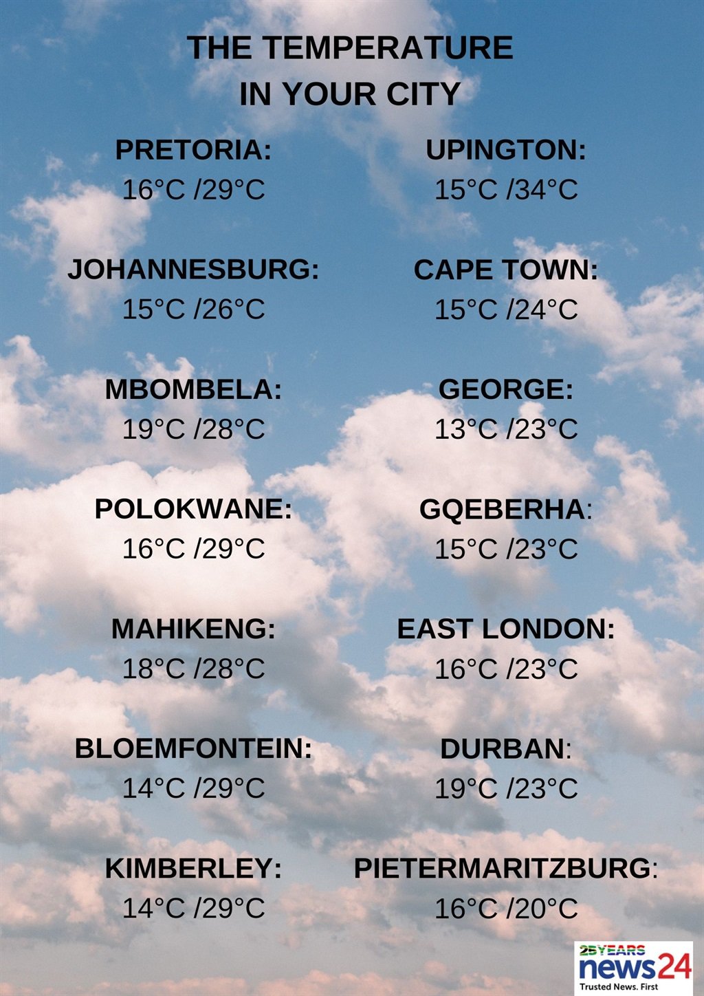
Weather in your region
Gauteng will be partly cloudy and warm but hot in places in the north with scattered afternoon thundershowers. The expected UVB sunburn index is extreme.
Mpumalanga will be cloudy in the morning becoming partly cloudy and warm with scattered afternoon and evening thundershowers but isolated in the north-east, where it will be hot.
In Limpopo, it will also be cloudy in the morning, otherwise partly cloudy and warm to hot with scattered afternoon and evening thundershowers but isolated in the east where it will be very hot in places.
It will be hot in the west of the North West, otherwise partly cloudy and warm with scattered afternoon thundershowers.
The Free State will be partly cloudy and cool to warm, with scattered afternoon thundershowers but isolated in the west.
In the Northern Cape, the weather will be fine and warm to hot, but will become partly cloudy in the eastern interior in the afternoon with isolated afternoon thundershowers in the extreme east.
The wind along the coast will be moderate to fresh south-easterly, becoming strong in the afternoon.
It will be cloudy over the interior and south coast of the Western Cape in the morning, becoming partly cloudy otherwise fine and cool to warm but hot in places along the west coast. The wind along the coast will be light to moderate south-easterly, becoming fresh to strong along the west coast in the afternoon. The expected UVB sunburn index is extreme.
The western half of the Eastern Cape will be cloudy along the coast, otherwise partly cloudy and cool to warm with isolated showers and rain in places in the south. The wind along the coast will be light westerly in places in the morning, otherwise light to moderate south-easterly.
The eastern half of the province will be cold in the western interior, otherwise partly cloudy and warm with scattered afternoon thundershowers but isolated in the north-west.
The wind along the coast will be light to moderate south-westerly, becoming moderate to fresh south-easterly from late morning.
KwaZulu-Natal will have morning fog over the interior, otherwise cloudy and cool but warm in the north with scattered afternoon showers and thundershowers. The wind along the coast will be moderate southerly to south-westerly. The expected UVB sunburn index is moderate.


Recent Comments